Project Overview
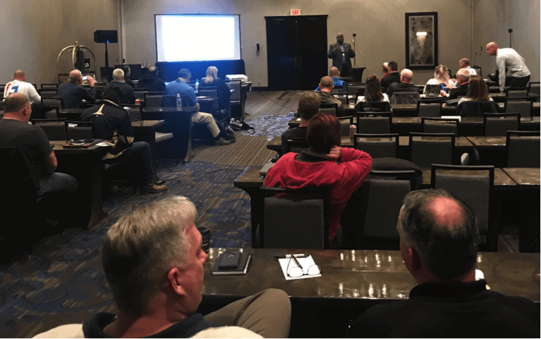
This year at IAFSM in Fort Worth Texas, Visual Plan was supported by 3D Forensic Technologist Helen Guryn from ai2-3D; a company who frequently tests and validates new 3D technologies. The conference focus was active shooter prevention and all venders attending would document a large mock crime scene.
Texas Ranger Troy Wilson and Omaha PD William Henningson setup 9 crime scenes in a large warehouse at Dallas Forth Worth Training center. The scene was a mock city with 2 floors and outdoors aimed at testing new equipment from each major manufacturer attending: FARO, Leica, Riegl, Trimble, Z+F, Geoslam and Visual Plan. This is what we learned from Visual Plan.
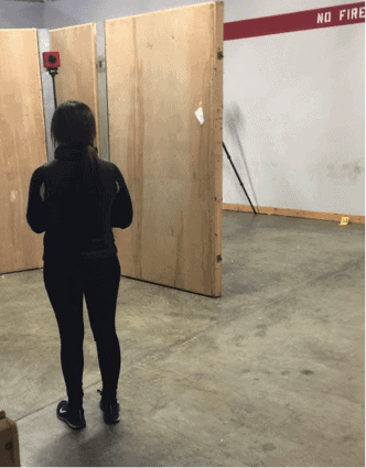
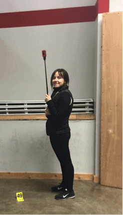
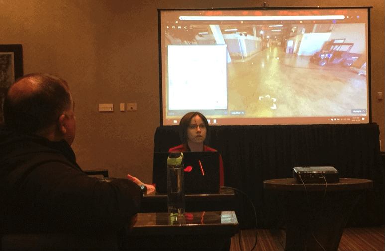
We only gave Helen a moment’s notice to learn a new method of field documentation, using tripod-less 360 photography and Visual Plan photogrammetry software. Receiving a Fedex package with camera and accessories late Sunday evening and given only 20min instruction over the phone, Helen was able to successfully document the entire crime scene in less than 4hrs Monday morning, indoor and outside. She was uploading the images to process that same afternoon. A completed scene was ready the next day.
Helen Guryn – ai2-3D
“The camera was super easy to use, as easy as holding up a phone and taking a selfie. The fun part is that documentation is really fast – one picture takes about 2 seconds. At the end of the day, you get a fully documented massive scene with the ability to measure directly using photos, and you get your steps with little effort or training” Helen Guryn from ai2-3D – 3D Forensic Technologist
https://players.visualplan.net/embed.html?key=Mcbzz4c3
Visual Plan is a 360 imagery and photogrammetry software with cm Accuracy where 3D Laser Scanner can deliver mm Accuracy. The advantage of Visual Plan is that you don’t require a tripod and can document the scene with a low-cost camera at walking speed. This affords large scale documentation in a fraction of the time taken to laser scan or traditionally measure a facility or crime scene.
Working in the 3D Laser Scanning market for many years, I know first-hand the challenges presented when scanning large facilities. Technology has rapidly evolved and these manufactures show great progress reducing capture time, offering higher resolution outputs and auto-registration progresses. The issue is that we don’t often require the level of accuracy required by 3D scanning and both time and cost are the sacrifice. We could look at using 360 imagery to document a large part of the facility and focus the 3D Laser scanning where critical measurements for BPA, Trajectory and key evidence collected that require high accuracy.
So how do we relate 3D visualization with building security for large facilities?
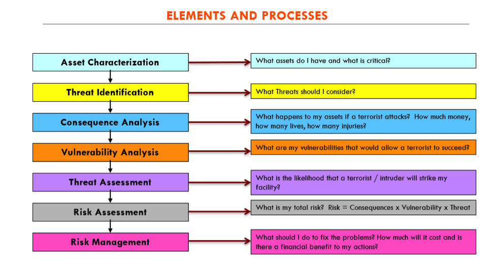
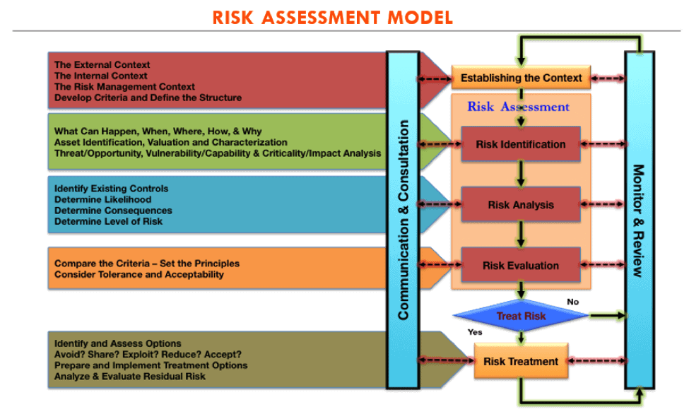
Former United States Secret Service Agent and Visual Plan Security Expert Clarence Jorif (CJ) spoke about these topics at the IAFSM. Outlining a thoughtful approach to security and risk assessments, CJ detailed how the approach to building security is multi-layered and offered advice on how 360 Visual Documentation can be used at each level of the assessment process (materials licensed through Newcastle Consulting).
Starting with key asset identification and characterization, a security expert typically walks a property taking notes and photographing of key assets, placing a value and prioritizing their importance to the organization. Visual Plan is invaluable to this step allowing the security expert to virtually visit and return to the facility at any time. Visual Plan offers 360 orientation, the ability to take measurements and understand different perspectives while sharing with other stakeholders.
The next step is organizing key stakeholders into a risk management team to discuss and decide on what key threat identification is mission critical to consider. From identifying these threats the team can critically think through a consequence analysis of what happens if bad actors are successful with their threats. Stepping the team through these scenarios Virtually and discussing scenarios in detail is valuable.
The next step is working on a vulnerability analysis, prioritizing them and determining a list of countermeasures in the security recommendations report. The visual documentation allows security professionals to see how design considerations relate to the space without having to visit the facility in person. Reviewing existing physical and process/policy vulnerabilities, Visual Plan allows stakeholders to visually inspect the facility, take measurements, provide notes and recommendations while understanding orientation and situational awareness when designing security countermeasures.
Both the threat and risk assessment components can use the visual documentation to confirm and deeply understand the nature of the threat, or risk, while evaluating how the countermeasures proposed will be put in place.
The last and most important part of the assessment model is risk management review. Visual Plan allows review through the design and application process to ensure it meets intended goal. We must ensure the countermeasures are meeting current, new and changing threats or risks as things change over time.
With so many options to consider for 3D Documentation, what is the best method?
If you have worked with 3D Scanners in the past like I have, you will understand the challenges with small spaces, that line of sight in spaces with obstructions requires more tripod movements making large spaces time consuming to document. Given the major leap forwards in technology today, time has decreased significantly. However, taking a 360 photograph every 2 seconds, or using 360 video documentation will always win the speed test over tripod-based scanning where anywhere from 2 – 12 minutes is required to complete a single scan.
Visual Plan does not claim mm accuracy necessary for applications like blood spatter, trajectory analysis or critical measurements for testimony, but I would like to open the mind to different methods to capture visual documentation on large facilities, similar to how drones have disrupted 3D Documentation outdoors. Leveraging both 3D Scanning and 360 imagery could prove an effective workflow to security documentation (pre and post-design), or for preserving large crime scenes where both goals of documenting a large space and preserving critical measurements are necessary.
So how does Visual Plan Work?
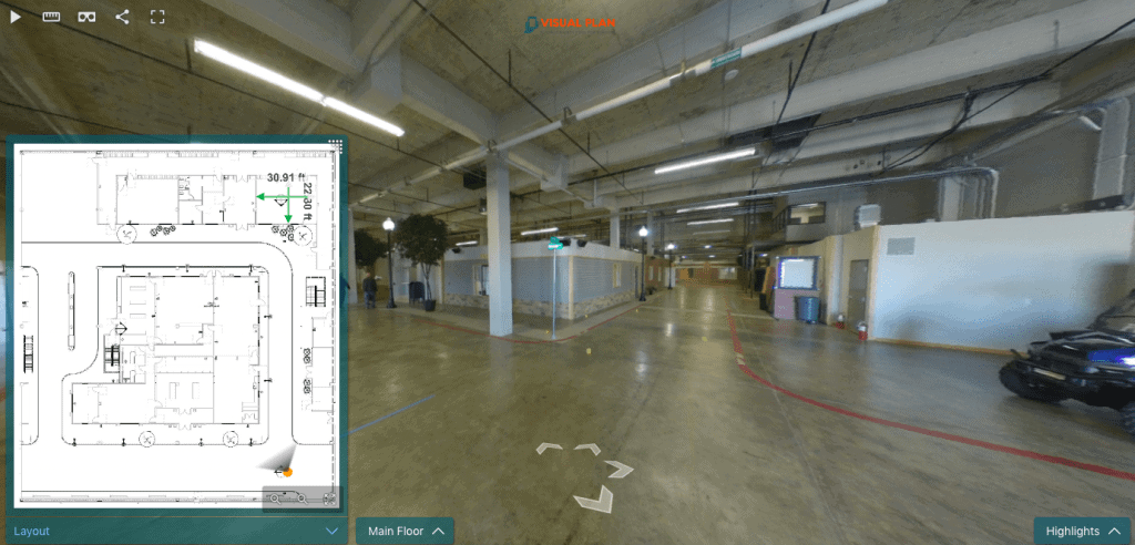
The key to Visual Plan is really the simplicity and rapid speed of the documentation mixed with the photogrammetry genius used in the Visual Plan software. Taking 360 photographs in sequence every 3-5 steps, at 65’ (20 meters) range, the Visual Plan Software can achieve +/- 1%-dimensional measurement error rate, so long as the setup and workflow is completed correctly.
LEARN MORE: https://visualplan.net/accurately-measure-dimensions-with-1-error-rate/
Post processing is completed in the cloud with AWS Government Secure confidence, while very little user input is needed. After the panos in each building section are aligned and photogrammetrically processed, we require 1 known measurement to scale each section, and then to identify the ground plane. In the case of this Crime Scene, I did not have reference measurements outside, so I used Google Earth Pro to get a very rough scale. As a result, my measurements will be very rough. However, I used measurements from a FARO scanner on the top right room on the main floor and the results are extremely accurate.
Less than 4 hours was spent putting these sections together, creating highlight quick-links and creating a visual walk-through of the crime scene. More could have been done linking video, crime scene photos, documents and reports, all of which can be done quickly, easily and securely in Visual Plan.
Moving beyond 360 documentation to 2D and 3D CAD Drawings, Visual Plan is uniquely built to create diagrams from only having imagery and get the job done quickly. See video below.
https://players.visualplan.net/p/Mcbzz4c3
https://visualplan.wistia.com/medias/zbbt5l9dsc?wvideo=zbbt5l9dsc
Conclusions
Photogrammetry is not new to law enforcement or security professionals, but gone are the days of leveling tripods, chasing targets blowing in the wind, or using complicated software applications to get simple measurements or results. Similar to how laser scanners disrupted the survey market and drones disrupted the outdoor documentation in many forensic and security applications, I believe the same is coming for 360 imagery indoors today.
Call us today to learn how we can help you reduce time, increase quality of your exhibits and capture everything painlessly.
Sincerely,
Kelly Watt | Founder and CEO | Visual Plan Inc.
Kelly@visualplan.net | 1 (407) 845-9010 | www.visualplan.net
For security and facility management applications please read my article in Security Informed speaking about large building documentation using 360 imagery and 3D Laser Scanning.