
Burns & McDonnell
Burns & McDonnell is a family of companies with an unmatched team of 7,600 engineers, construction professionals, architects, technologists and scientists.
360 CAPTURE SPECS
camera Ricoh Theta Z1
capture site 24 Electrical Substations Across 4 States
capture size > 2.5 million square feet total
capture time <1 day per site; 8 business days, 10-12 hours / day.
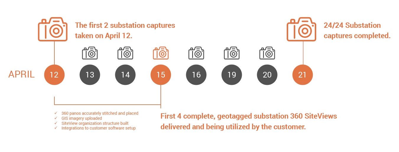
capture date Captured April 12 – 23, 2021; full project delivery May 7, 2021.
ABOUT THE APPLICATION
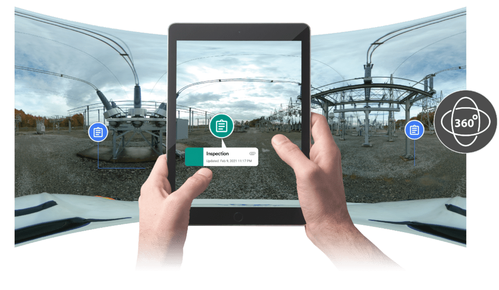
Electrical substation capture to manage security design repair and upgrades.
project dates Ongoing
location Missouri, Oklahoma, Arkansas, Kansas
capture sites Municipal buildings, aquatic centers, public parks, public school districts
Earlier this year, one of the largest independent retail and non-residential electric providers in the United States and their construction engineering firm trusted Visual Plan as their visual data hub to capture and process over 2.5 million square feet of 360 photogrammetry as part of an ongoing, multi-site security system design upgrade project.
In April 2021, Visual Plan worked with partner Burns & McDonnell to 360 capture and process the electric provider’s 24 substation sites. Using the Visual Plan platform as their capture platform and data hub, the customer was able to capture comprehensive, measurable visual data of each site without the exorbitant financial and time requirements of terrestrial Lidar data.
“For this substation project, Visual Plan worked in a way that no other scanning company that I’m aware of could have worked simply because of the time it takes to do a scan. We were doing 24 sites in about 2 weeks – we didn’t have time to spend multiple days per site doing 3D scanning. Visual Plan allowed us to do 2-4 sites per day.”
– Brock Josephson, Physical Security Specialist, Burns & McDonnell
The 360 capture process took place over 8 business days; with electrical substations located across Missouri, Oklahoma, Kansas and Arkansas, 2-4 sites were captured per day based on proximity. Using hardhat and tripod mounts, full captures were produced of perimeter fencing, substation assets and all required control rooms for at each substation, averaging 100k square feet each. The first capture was taken on April 12th, and by the 15th the first 4 substations’ SiteViews were fully processed, geolocated, and ready for customer use, annotations and collaboration.
“Typically for a substation security upgrade or rebuild project, stakeholders would walk through 20 substations in a week and be expected to rely on still photographs or remember the details of what they saw. With the 360 photogrammetry, it’s fast, complete visualization – every stakeholder can evaluate the project and make decisions using the same visual data.”
– Erik Irrgang, Visual Plan
By importing Eagle View GIS imagery, the Visual Plan platform was able to effectively constrain the 360 data, merging both Aerial and terrestrial capture for this project, in addition to the available CAD drawings and new design files in creation. With the captured 360 photogrammetry and the Visual Plan platform as their data hub and collaboration tool, the electric power company customer is able to have accurate, virtual, on-demand access to walk through each substation site to review, confirm or evaluate proposed security and rebuild projects.
KEY ROI:
- High Customer Satisfaction toward Visual Plan collaboration tool
- 83% reduction in capture & deliverable turnaround timeline (from 6 months to 1 month)
- 10x cost savings over entire site Lidar capture, while allowing for Lidar at critical locations
- Site visits and travel costs reduced exponentially across customer management and project teams – 21 project users and over 50 additional stakeholders are benefiting from virtual walkthroughs during the first 90-days and data will be re-used over and over again over the project lifespan and later
Challenges: Restricted Site Access and Unavailable As-Built Imagery posed security design challenges
With substations spread across 4 states, logistics challenges and safety concerns regarding stakeholders site visits, Burns and McDonnell needed a way to provide accurate visualization to the power company’s teams remotely. Additionally, a foundational survey of each site was beneficial to prepare not only for the immediate security design upgrades but also longer term planning for subsequent upgrades to access control systems, cameras and additional security countermeasures slated for 2022.
Due to ongoing maintenance, construction and expansion at the various locations, Google satellite imagery was outdated and did not provide the level of detail needed to accurately plan the security upgrades. Similarly, CAD drawings were either outdated, incomplete or nonexistent for the sites, requiring measurements to be gathered from each location.
Without comprehensive visualization of each site, on-site visits were going to be required for a significant number of stakeholders from both Burns and McDonnell and the power company, increasing time, travel costs and safety risks.
“We required a measurable, visual record of each substation that allowed us to measure standoff distances for overhead lines, review any obstacles to the new fence designs with stakeholders, and collaborate on security assessments – all without needing to be on-site and with a fast turnaround time.”
– Brock Josephson, Physical Security Specialist, Burns & McDonnell
Solution:
For the multi-site substation security assessments and fence design project, the lower cost, quick turnaround and scanning services of Visual Plan significantly outweighed the benefits of point cloud scanning options. To capture each location, a Visual Plan representative outfitted with the Ricoh Theta Z1 360 camera, a hardhat and a tripod walked each substation using the platform’s built-in video and multi-shot capture methods.
Using Visual Plan as a visual asset management hub helped expedite both the capture and processing of 360 panos for each site, as well as develop a hierarchical organization for the group of substations and each individually. Because of the remote locations of the substations, Visual Plan acquired high res GIS imagery to function as an underlaid image to which each site’s captured 360 panos were georeferenced. By using Eagle View GIS imagery at the foundation, Visual Plan was able to effectively constrain the data merging both aerial and terrestrial capture for this project, in addition to the available CAD drawings and new design files in creation. Geolocating by latitude and longitudinal bearings, each site was placed into a macro-level overview of the entire portfolio of substations, with each individual location having its own SiteView for detailed drilldowns, virtual walkthroughs and annotations.
Virtual collaboration between stakeholders was required to review ongoing repairs to the physical security systems, such as fence height clearance to overhead wires, AC power locations, identifying necessary repairs, sharing design code annotations and recommendations. The Visual Plan SiteView allowed for in-environment annotation, measurements within a 1-foot accuracy, and integration with ProCore for streamlined review, project planning and decision-making across both the customer’s and Burns and McDonnell’s teams.
“The electric power company customer and Burns & McDonnell are already reaping the benefits of project sharing through integrated ProCore PM tools, annotations and streamlined visual data sharing. Visual Plan has enhanced their collaboration over the standard 2D drawings and still site photography used in the past. The team shares SiteView links with stakeholders and during virtual tabletops – everyone has access to 360 visuals for verification moving forward.“
– Erik Irrgang, Visual Plan
Critical Features for Success
Out of the box, Visual Plan is optimized to use GIS data for each captured pano to accurately place and stitch together a large square footage across multiple sites – a feature critical to the speed and accuracy required during the substation capture process. Leveraging Visual Plan to its fullest potential, the annotation, measurement and sharing functionalities were immediately utilized by the customer as a critical collaboration tool as the security design upgrade project progressed.
“Utilizing the platform as part of virtual meetings about the project has been a huge success, and the virtual walkthroughs have given peace of mind to everyone involved. During the on-site walkthroughs, I hardly took any photos at all. Whatever I would have taken with still photos, I can see and show our stakeholders 10x better in the 3D scan, and then from there drill additional photos or notes of detailed spaces or cabinets that we might need.” – Brock Josephson, Physical Security Specialist, Burns & McDonnell
Critical Benefits:
- Barrier to entry was low regarding the capital investment
- Visual Plan performed all capture, processing and delivery
- Easy import, scale and alignment of floor plans to GIS via Import Floorplan Wizard
- Intuitive organization of 360 panos across areas and spaces (accelerated via the Visual Plan Capture App)
- AI spatially and accurately aligned the panos automatically
- In-environment annotations, documentation and measurements
- Sharing/Reporting via deep links and remote viewing
360 is Faster, Safer, Less Costly: Financial Savings From Reduced Site Revisits and More Accurate Decision Making
With a quick capture and processing timeline, low capital investment costs and integrated tools for streamlined collaboration and decision-making, customer satisfaction of the Visual Plan platform, and its capabilities was very high for this ongoing electrical substation repair project.
“We had the first couple of sites ready to be viewed within a few days. All of the sites delivered within 2-3 weeks. With an alternative Lidar scanning system, it took about a month to get the data from just 5 substations versus 2-3 weeks for all 24 with Visual Plan.”
– Brock Josephson, Physical Security Specialist, Burns & McDonnell
Low Capital Investment:
With Visual Plan’s built-in 360 capture and processing capabilities, the estimated 6 month timeline for lidar capture and processing was reduced to less than 1 month for completed, customer-ready deliverables. In addition to this time savings, utilizing the Visual Plan hub for capture, processing and data storage required 20x less capital investment costs than terrestrial lidar options, saving money on hardware, necessary operator expertise and data storage requirements.
Reduced Site Re-Visits & Travel Costs:
An average electrical substation site visit includes 2-4 representatives from the A&E firm plus 1-3 individuals from the electric provider. Since the capture and development of their SiteViews, Burns and McDonnell has been able to hold virtual site visits with the customer, reducing the need for site re-visits, saving on the hourly time and travel costs of 7 individuals each site visit.
With the virtual walkthrough capabilities, the initial site visits conducted by approximately 10 individuals during the capture process now serves as the foundational visual data for 21 authorized users and over 50 additional stakeholders during remote tabletops and virtual walkthroughs. The financial and time savings of these reduced in-person site visits continues to grow exponentially as the electric power company uses the Visual Plan SiteViews over the lifetime of the project.
Improved Project Accuracy & Decision Making:
Working with outdated 2D datasets and satellite imagery can cause issues. The 360 capture and processing assists in developing 2D birds eye view mockups of the substations, complete with annotations and in-environment markup. Additionally, the 360 scans show accurate, as-built representations of facilities, surrounds, spatial relationships and asset orientation.
Capturing 24 Electrical Substations in 8 Days Was Just the Beginning of Their Success:
Finding success in Visual Plan as a strategic collaboration tool, both Burns and McDonnell and their electric power company customer have benefited from the project certainty provided them from having as-built visual data at their fingertips. Within the first 3 days of the 360 capture process, the customer was using the current 3D visual information to identify and tag necessary repairs, add in-environment annotations, and collaborate in real time across internal and external teams.
While the cost and time savings of 360 capture are being immediately realized, the longer-term life cycle of the virtual walkthroughs, annotations and documentation are anticipated as project planning takes place beyond the initial security system upgrades. Post-upgrade recapture across sites is not cost-prohibitive and will yield comparable data to further inform future construction and expansion across substation sites.
“We completed 24 site assessments but some phases of the project will not begin until 2022. With Visual Plan we don’t have to rely on our memories and photos alone. We will see the long-term value of having a comprehensive visual record of this data when we begin some phases in 2022 and have to refer back to data we gathered this year for design.”
– Brock Josephson, Physical Security Specialist, Burns & McDonnell
About Burns & McDonnell
Burns & McDonnell is a family of companies with an unmatched team of 7,600 engineers, construction professionals, architects, technologists and scientists. Their singular mission since 1898 has been to make their clients successful. Burns & McDonnell delivers projects with an integrated construction and design mindset, because everything is connected — design, procurement, sequencing the construction site. They leverage knowledge, technology and commitment of ownership to deliver safe, innovative and quality projects.