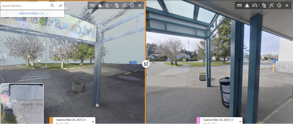
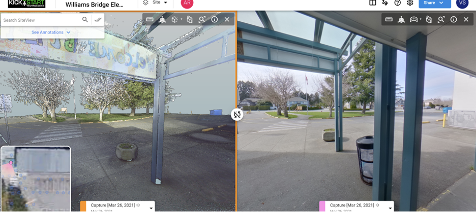
Visual Plan Hub is a collaboration software platform that compiles all things CAD and all things 3D to manage Digital Twin comparisons. The 360°photogrammetry engine captures change and is placed in sync next to other 360 captures, BIM, Lidar Point Clouds, SLAM and overtop of 2D-CAD, GIS and drone topo-mosaics to provide a baseline of truth for entire teams and organizations.
From Inspection to Design, Project Management, Construction, Commissioning and Asset Management
Inaccurate information from facilities and assets is a critical problem during the inspection, assessment, and audit processes, especially with existing and older facilities. Silos of information are collected by different stakeholders for various purposes, but not contained in a single system of record. Photography, survey measurements, site sketches/diagrams and new design concepts are often created independently and as a result of various individuals repeating similar tasks for their own needs. This is very inefficient, increases project costs, and leads to miscommunications, potential clashes, change orders and rework. Moving from file sharing to a single system of record is critical to ensure all stakeholders have access to the same complete site documentation and visualization. For many industries, 80-90% of site-visits can be eliminated with the use of accurate 3D Visualization.
Cost increases multiply with hard-to-reach areas like offshore assets, air-access-only towers, with assets requiring climbing/scaffolding or where health and safety risks come into play such as with power, energy, chemical and manufacturing environments. Secure facilities also add many layers of approvals, safety training, insurance, and administration to escort site visits. Technology can make a huge impact here moving from binoculars on the ground to close proximity drone flights and 360 capture video.
Digital Twins significantly help to reduce these issues. But which technologies should be used for the project scope and need? Aerial vs Terrestrial Capture? Photogrammetry vs Lidar? 3D Model vs 360 Visual Tours?
The Visual Plan Hub software platform can be used to review, compare, annotate, share and report from all of these types of data in a single interface that requires zero training and can be shared from the CEO level to the line-item worker. 3D Digital Twins should be used by entire organizations, not restricted to a few engineers in the field.
Safety, Security, Operations and Compliance
Safety, Security, Operations and Compliance are example areas where digital twins have not fully adopted. These departments have struggled to gain accurate facility information from their counterparts in engineering, or partner design companies likely because the data historically has been complex to create, expensive, time-consuming, and requiring highly technical knowledge and software applications to capture, create and share. That is no longer the case with the evolution of 360 capture. Low-cost 360 cameras and software applications like Visual Plan put the power of survey into the hands of operations or support services to capture, create share and report. With very little training entire campus facilities can be captured and critical visualization recorded, chronologically organized and available to compare at anytime in the future. The ability to record change, archive subterrain assets, or behind walls or above ceilings is amazing. The 360 provides invaluable information to the CAD/BIM team to manage changes but will not replace the accuracy of 3D Lidar for reverse prototyping and critical engineering tasks.
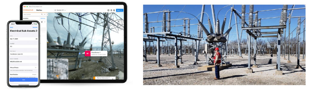
Hazardous areas or high value assets from critical infrastructure like the power grid can gain greatly from digital twins given the number of remote locations and challenges with site visits and organizing all asset information seamlessly.
Design Planning
Managing security design layouts in 3D is far more effective than placing camera icons on inaccurate models and hoping for the best. Likewise, inspections, assessments and audits gain huge value with a complete cloud base record of truth displaying everything and anything they would want to see on a site visit. Site information is critical for design and collaboration of existing facilities and for critical thinking through iterative design process and approvals. Incomplete information can lead to mistakes, change orders and rework, or to further site visits, time and travel to validate information on the ground.
Communication breakdowns occur with misunderstandings over incomplete information and difference of understanding of what something means to various individuals. The equalizer if 3d visualization where undisputedly we can verify with our own eyes what we see, measure and understand to be true, giving us more than a focal shot of a single photo, we have full situational awareness of the space, egress, furniture and true as-built condition.
Project Management
Widely used project management tools are gaining a critical edge today with the implementation of 3d visualization and digital twins. Virtual site access to the project helps to mitigate scheduling conflicts, clashes and rework as 360 capture is implemented daily or weekly on active job sites. Scheduling 360 capture daily or weekly on an active project and feeding the 3D visualization to Autodesk PlanGrid, BIM360 or ProCore (bi-directional sync available to all 3) allows Visual Plan Hub users the benefit of annotating visually and pushing these comments to project management seamlessly.
Managing Operational Change, BIM and CAD
A key value of Digital Twin Technology is the ability to simulate iterative designs concepts, scenarios, and processes before approval and implementation. Reduced mistakes, change orders, costs savings and just better overall design and implementation can be achieved with good use of Digital Twins. But what comes next during the commissioning and project handover to facilities?
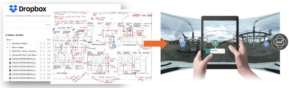
The data dump that typically happens when a construction or improvement project is complete often leaves the Facility Manager with data overload and data silos managed by a few in the organization (typically engineering). The process of migrating this construction data to facility or asset management systems can be complex and time consuming, but if done properly, worth its weight in gold.
A software tool like Visual Plan Hub can be a tremendous help with the organization and migration of as-built information and provide a path to ongoing visualization to help manage operational change. Visual Plan does not map complete fields from BIM to CAFM (Kobe to Uniclass2) but does provide a quick and easy spatial bridge between visual assets (360/Lidar/BIM/GIS) to the operational world of work orders and preventative maintenance. Still most organizations live in a less desirable world. A world of scouring old and inaccurate blueprints. Without trust in what information available, the common practice is to pull out the camera and tape measure and return to the site visit to “see it to believe it” with your own eyes. As is the case with many operational and facility service support people who don’t have access to accurate data. Consider that facility operations today spend more than 40% of their time trying to find or show someone something onsite.
As stated by Solomon and Associates, 1% increase in mechanical availability 10% reduction in maintenance cost annually.
Data quickly becomes dated, loosing value as facilities change. Having a quick and cost effective method to frequently capture and update building information or inspect assets becomes very valuable, especially when investments in BIM and Lidar are made. Capturing, sharing, annotating/asset tagging, reporting, and managing current as-is facility or asset conditions is quick and cost effective with 360 and Visual Plan Hub.
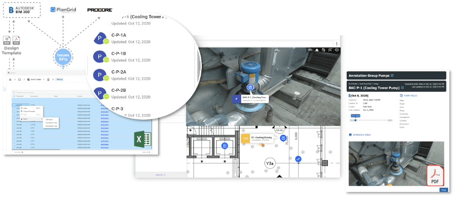
Commissioning a project by spatially asset tagging critical information to the Digital Twin (manuals, documents, photos, video, asset properties…) allows entire organizations to access asset and facility information through Visual Plan at anytime from anywhere for any purpose. Whether the access point is through project management tools like ProCore/PlanGrid/BIM360 or CAFM/Asset management software, Visual Plan Hub is the gateway to spatially organize, link and catalogue visual Information over time.
Preventative Maintenance
Repeatable preventative maintenance and safety programs are easy to implement with digital twins as new employees gain critical information through visualization rather than having reliance on experienced managers. The larger and more complex the facility, or the more people involved with managing a facility give a higher significance to the value of digital twin information.
Capturing 360 and 3D Data
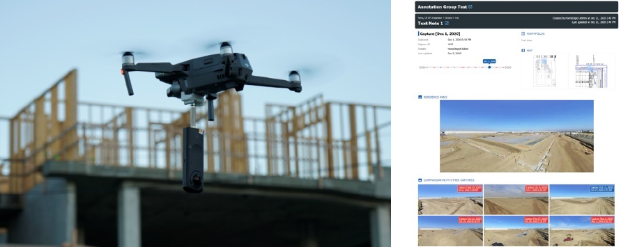
When considering the collection of 360 or 3D information, we can classify capture into 2 spaces: Aerial and terrestrial. Most Aerial data is collected by a variety of drones or airborne technologies, or from pole mounted photography or 360 photogrammetry on the ground (see below). The deliverables include creation of a point cloud or mesh model, ortho-mosaic imagery, and fixed position high resolution imagery from cameras and/or video attached to the drones.
Aerial Capture
Adding 360 cameras offers new and exciting opportunities as Visual Plan can process 360 immersive tours from the 360-capture reducing the need for drone mesh models or point clouds. Furthermore, the 360-camera lens are mounted horizontally facing vertical asset offering much greater clarity front a front facing perspective view either from a belly or top mount on the drone.
Using your standard drone flight software and attached 360, simple start the video and follow your flight pattern. On assets, capture orbits and various elevations. On completion, clips the 360 video into segments and load to Visual Plan for auto-processing and alignment to the GIS or 2D CAD. Feel free to import the Mesh Model or Point Cloud for comparison data, but you will get far greater detail from the 360 image than the mesh model.
Drone utilities capture 22% of available information on assets like towers, leaving more work to be done from the ground (terrestrial capture). Visual Inspections form the ground using binocular are antiquated now that we can elevate cameras on poles and place them on drones. And many of these assets have indoor spaces to capture like control rooms or associated facilities. This is the perfect space for a terrestrial 360 capture solution or Lidar if accurate structural as-builts are needed.
Terrestrial Capture
For small and confined spaces, the 360 camera offers enormous opportunity. Dropping a camera on a pole with attached lighting kit into sub-terrain space removes the operator from climbing down. Tight spaced communication or electrical control rooms can be completely documented, and assets tagged with a handful of 360 images. Remote substations, offshore oil platforms or inside wind turbine towers can quickly be captured with 360 even in questionable lighting conditions. And capture can be completed by onsite staff, or the climber who needs to enter the space for other business.
Traditionally terrestrial capture has been slow, working with tripods and line of sign limitations especially in crowded indoor spaces where overlap is needed to make sense of the data. The 360-video capture has massively disrupted this capture process where huge areas can be captured at walking speeds.
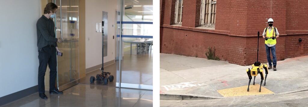
From the ground, 360 imagery/photogrammetry can be captured with low cost 360 cameras fixed to a hard hat or pole while walking an inspection on site. The workflow is fast and easy. Other capture methods such as camera or scanner attached to the Boston Dynamics Spot Dog or through Visual Plan 360 Rover offering extremely fast mobile imaging and nearly autonomous capture. When compared to tripod captures, there is no comparison for speed.
The Visual Plan 360 Rover solves further problems in low roof areas and to create consistent linear data while removing the operator from line of site. For contiguous spaces like University Buildings, the capture workflow is painlessly quick. Visual Plan has also integrated with Boston Dynamics robot (SPOT) for a higher degree of control and semi-autonomous operation. When terrain is difficult and remote capture is required, SPOT offers some unique advantages as a delivery device, albeit with a much higher price tag.
Choosing the Right Capture Method
Photogrammetry “AND” Lidar
When projects require 3D modeling or critical measurement, lidar or traditional survey is often a required solution. Most 3D scanners come with a 360 camera as the visualization is critical to understanding the space. Yet deploying lidar at every stage of a design project is not always practical. The speed and completeness of documentation offered by 360 capture can significantly aid the modeling process, especially as change is made through that project. Whether attached to a drone, tripod, or mobile handheld/backpack, the benefits of lidar’s accuracy also come with big data, complexity, and often a large price tag. Using the right tool for the job is critical here. Considering a hybrid approach to applying lidar to areas where it’s needed but gaining the speed and low-cost capture benefits from 360 photogrammetry for areas lidar is not required can prove very efficient.
Given the variety of terrain, facilities and asset information needed for various project work, having an effective strategy for both Aerial and terrestrial capture is critical. Considering which device to attach the camera or Lidar sense will depend on the environment and space. And no matter what capture method you decide on, Visual Plan Hub can be the single system of record to organize, manage, compare, share, annotate and report on the data collected. Visual Plan helps to remove data silos and enable entire organizations to gain value from your Digital Twin program.