Kestrel Group LLC
The Kestrel Group provides Aerial Compliance Solutions including drone inspections, thermography, and methane and VOC detection services.
THERMOGRAPHY CAPTURE SPECS
environment drone equipped with thermal camera at 30° angle
camera FLIR Boson 640R
operator Thermographer II
method combined ladder pattern with circular route capture
surface distance 20ft off surface of the tank
capture time 3-4 hours per tank
data processing 2 hours
data delivery 48 hours
360 CAPTURE SPECS
camera Ricoh Theta Z1
capture method HDR tripod inside tanks, walking helmet cam and pole on exteriors
capture time < 90min
field upload time 20min
data processing time 30min
data available project collaboration started same day, while on-site
With proven results in the field, Visual Plan and Kestral Group have developed an innovative combination of drone-capture thermography and 360 photogrammetry to enable geolocating and tagging of anomalies within a virtual walk-through.
Partnering with drone thermography expert Scott McGowan of Kestrel Group Aerial Compliance Solutions, Visual Plan integrates 3D Digital Twins into a safer and more cost-effective tank integrity management workflow by expediting the capture, organization and correlation of qualitative thermal imagery into accessible and actionable geo-located data, yielding:
- Reduced inspection costs
- Improved safety
- Higher-quality thermal imaging
- Fast data delivery
- Environmentally friendly approach

“Visual Plan’s 360 photos of a tank site—or other critical infrastructure environment—allow for in-environment tagging of individual thermal photographs into the 3D world, providing an actionable location of each identified anomaly, as well as any corresponding data associated with the thermal scanned assets. This efficiency in identifying, locating and understanding the asset information directly translates to realized time and cost savings.”
– Scott McGowan, Kestrel Group LLC
Challenges: Current Tank Surface Inspection Methodologies Lack accuracy, granular detail and Intuitive Geo-Locating of identified anomalies
Visual tank inspections are a critical component of any integrity management program, however more detail is needed than can be seen with the naked eye. Existing qualitative inspection and thermography methods for storage tank exteriors are time consuming, costly and high-risk, and have marginal quality results:
- scaffolding ($$$$): erecting scaffolding around the exterior of a storage tank is not only extremely costly, in the 10s of thousands of dollars, but also requires additional safety training and approvals, engineer inspection and sign-off, extensive equipment brought in and out of the environment, and long lead times for installation and tear-down.
- helicopter mounted inspection ($$$): a typical inspection method, leasing helicopters with thermal and photo imaging capabilities provide aerial access to a tank at the cost of accuracy, image quality, surface distance, safety, environmental impact and investment costs. Helicopters are unable to get close enough to a tank to provide the granular detail needed for accurate anomaly identification.
- binoculars/telephoto cameras ($$): while somewhat more cost effective, utilizing telephoto apparatuses from the ground is the least accurate method of inspecting tank exteriors, and does not provide a uniformly comprehensive visual of the tank surface and roof.
- manual inspection and documentation ($$): engaging personnel or external service providers to manually inspect a tank surface requires significant time and yields disjointed documentation and still images lacking context and clear anomaly location, and rely on the inspector as a singular source of knowledge regarding the tank’s conditions.
Once an inspection method has taken place, the anomaly photos and documentation are typically held in separate folders or files, lacking context of where the anomalies were located, on which tank within a terminal, or inspection and repair history of the associated assets.
For this chilled tank inspection client, their previous inspection methods had proven costly and inefficient, with the latest thermal imaging having been captured via helicopter 9 years prior. With safety, data quality, cost and data delivery time as their top priorities, McGowan of the Kestral Group and Visual Plan worked together to build a comprehensive thermal and 360 photo walkthrough of the tank site to meet the client’s needs.
Solution: Using Drone-Capture Thermal Imagery to Detect Anomalies & 360 Digital Twin to Expedite Remediation
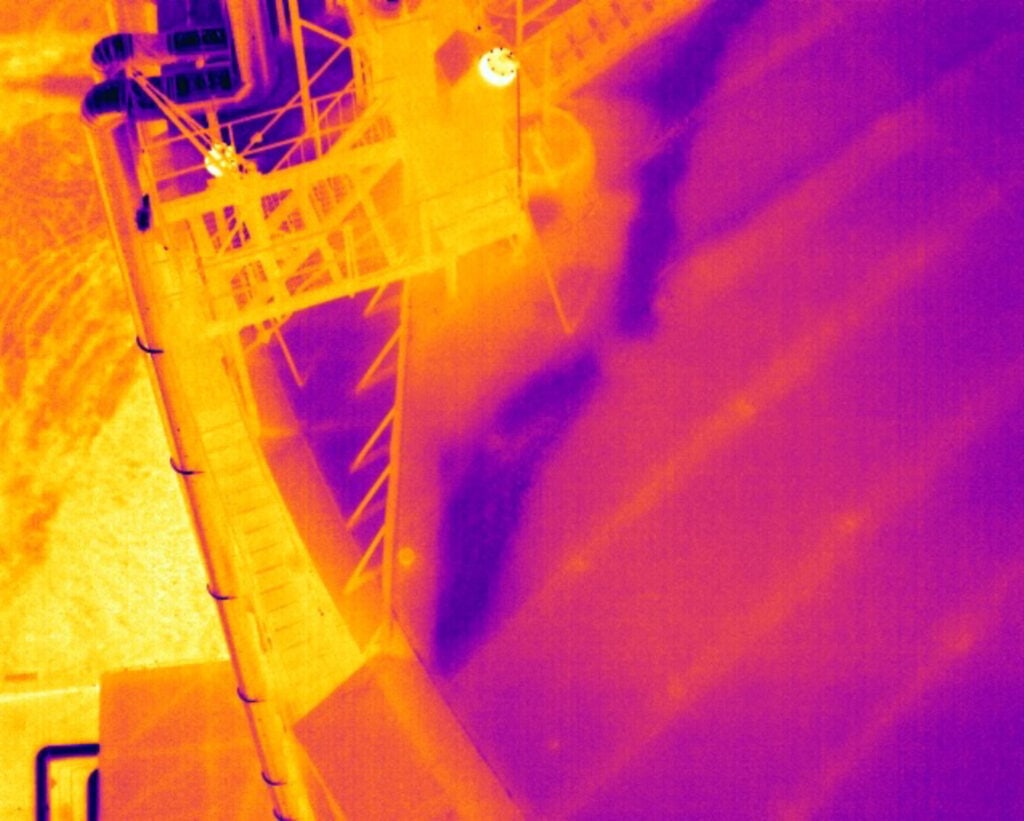
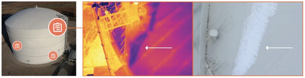
Scott McGowan, 10-year drone pilot and Level II Thermographer, completed a qualitative thermal assessment on a 150’ diameter chilled tank at a 20ft surface distance and with 640×512 resolution using an innovative combination of drone and sensor technology. Stick-flying the drone in an overlapping ladder pattern, the comprehensive surface data collection was conducted in less than 4 hours in a single evening site visit. The resulting thermal report had a higher image quality at a fraction of the cost of the previous helicopter capture, and without the need for costly and dangerous scaffolding.
360 imagery of the tank and site captured with Ricoh Theta Z1 camera was used to create a virtual walkthrough of the location, and to spatially correlate tank assets, documentation and inspection data within the 3D environment. Using the produced Digital Twin, the thermal imagery was accurately correlated by location on the tank, providing accessible and easily identifiable comprehensive documentation on the tank’s integrity and any found anomalies.
Successful integration of drone-captured thermal imaging into a 360 virtual walkthrough environment:
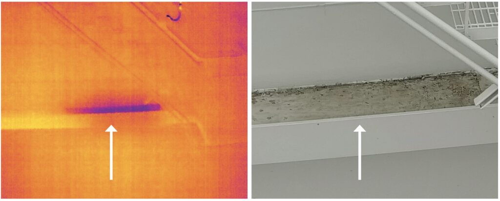
- Thermal imagery inspection provided very granular and accurate data, sensitive enough to capture areas of flecking paint and previously completed repair work
- Drone capture was faster, cheaper and safer than current methodologies, saving tens of thousands of dollars per inspection
- 360 virtual environment and information tagging provided comprehensive, organized and actionable geo-located asset data and thermography results
- 360 virtual walkthrough of the site allowed for remote oversight, reduced site visits post-inspection, and ongoing tank maintenance knowledge management
Conclusion: Combining Thermal Imaging and 360 Photogrammetry into the Tank Integrity Management Process Improves safety and expedites decision making
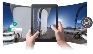
Incorporating thermal imagery into Digital Twins provides the ability to accurately relate identified anomalies to 360 imagery, and locate the findings in a virtually-walkable 3D environment. Thermal photographs, like regular photography, are often stored in folders or as part of separate reports. Without the association to the Digital Twin they can lose context, making anomalies difficult to locate, especially for other stakeholders tasked with remediation or repairs.
Experienced inspectors and technicians, equipped with drones, thermal cameras and 360 cameras, capture comprehensive exterior visual data to produce qualitative and quantitative thermal imaging reports, and a virtual walk-through of the tank site. The captured visual data is geo-tagged to expedite future locating of the specified tank and any thermal anomalies; and captured thermal imaging is digitally placed in-environment along with annotations to ensure data consistency and quality.
The resulting Digital Twin offers a unique platform for virtual communication and accurate understanding of the findings in relation to the site or specific assets.
Critical Features for Success
Kestrel Group and the clients continue to see benefits from implementing Visual Plan into the tank integrity management process. Internal teams can use the virtual walkthrough of the site to quickly locate discovered anomalies, view associated thermographic and rgb images of each anomaly, house and maintain asset histories and documentation, communicate effectively with remote and external teams, and streamline decision making all from a single source: the Visual Plan SiteView platform.
Critical Benefits:
- Visual Plan as a single source visual record of tank locations and asset details
- In-environment annotations to accurately locate and identify anomalies
- Comprehensive, organized and actionable geo-located asset data including still photos, asset histories, documentation and thermography results
- Virtual walkthrough functionality to enhance virtual review, oversight & decision-making
- Barrier to entry was low regarding the capital investment
- Simple auto and manual orientation of 360 imagery to 2D site plan to enhance understanding
- AI spatially and accurately aligned the panos automatically
- Remote access and secure sharing
About Kestrel Group LLC
Scott McGowan of Kestrel Group LLC is a former energy commodity trader with 20+ years experience. An innovative pioneer in the Unmanned Aerial Services industry responsible for numerous industry firsts and innovations, McGowan founded Precision Aerial Compliance Solutions LLC, a Tier 1 UAS services company and disruptor in the engineering, survey, oil and gas space. He serves as an Advisory Board Member of The Energy Drone and Robotics Coalition, is a familiar face and participant in numerous webinars and as conference keynote and panel speaker, and is a published author on UAS and LiDAR topics.